


![]()
![]()
![]()
![]()
![]()
![]()
![]()
![]()
![]()
![]()
![]()
![]()
![]()
|
9/05/07 Departing the
Pattern Tonight was the first
time I would
not see Mike when I flew. I was a little nervous as I drove to the
airport, but by the time I got out to the plane, I was too busy to
think about being nervous.
Before I left the airport, I checked the weather to make sure it didn't exceed any of my limitations. The only one that was close was the wind. I wasn't allowed to fly in wind greater than 12 knots. It was exactly 12 knots. I knew as the sun went down, the winds would die, so I was glad they weren't any higher. When I got to the airport, I started by picking up the logbook for the plane from the office. The new high school girl (that replaced the leaving high school boy) showed me how to use the safe outside the office if I got back after they were closed. They close at 8pm, and I had no intention of flying later than that. I took the logbook, and went out to the plane to do the pre-flight. The pre-flight was uneventful, except I had only 11 gallons of gas in the plane. The plane used 6 gallons per hour, and I was only intending on flying for one hour. VFR flight requires at least a half hour extra of fuel (another 3 gallons). Technically, I only needed 9 gallons total, and the 11 gallons would give me a little over an hour, plus reserve. I thought about it, and decided I wasn't comfortable flying alone with the minimum amount of fuel, so I called the FBO for more gas. I didn't have their radio frequency, so I used the Unicom frequency. Someone got on there and told me what the correct frequency was. It wasn't on my information sheet for the airport, so I wrote it on there. I have had trouble getting the fuel guy on the dedicated frequency before, but he was on the correct one tonight. He came out an filled the tanks. Now I had 24 gallons of fuel, more than I would need tonight. I started the engine and taxied out to the runway (8R). There was another student in the pattern. He was on Base leg when I finished my run-up, so I waited until he landed to take the runway. I made my radio call, and took off. My plan was to stay in the pattern for one touch and go before I went out to the practice area. I went around and did an OK landing. It wasn't one of my best, but I hadn't flown in a week, so I thought it was good enough. There was a slight crosswind that made the landing a little harder. I took back off and then departed the pattern to the west. It takes about ten minutes to get to the practice area. I wasn't sure, so I wrote down the time I left the pattern and the time I arrived at the practice area so I would know when to leave. Before my lesson, I wrote out a quick flight plan so I would not forget what I was supposed to do once I got to the practice area. I also wrote out what the Practical Test Standards (PTS) were, so I would make sure I was practicing the manuevers correctly. The first thing on my list was slow flight. I set the plane up for slow flight and flew around for a few minutes going about 45 knots. Then I pulled out the power and pulled back on the yoke to get close to a stall. Mike didn't want me to actually stall the plane, but just get on the verge of stall and then recover. I played around on the edge of the power off stall for a few minutes. Then I decided I was comfortable enough to make it actually stall. I pulled back and recovered without any problem. Then I had to practice recovering from a power on stall. This one feels like you are pointed straight up. I know I am not, but it is a much higher angle of attack than the power off stall. This time, I did not feel comfortable enough to do a full stall, so I brought it right to the edge of it and then recovered. I am going to have Mike give me a few pointers on the best way to set up for one. I still need practice in this. Then I practiced some steep turns. They are at 45 degrees, but it feels like 90 degrees. When you look out the side window, you are looking directly at the ground! Mike gave me some pointers on them the last time we were in the practice area together. I used those pointers and did some pretty good steep turns. They were all within the PTS, so I felt good about them. That was all I had to practice for tonight's lesson, but I wanted to try turns around a point and S-turns across a road, also. I tried them both, but I was too high, and my set-up for them was not good, so they didn't turn out so well. The sun was starting to set, so I was hurrying a little bit. There will be plenty of time to practice them later, so I decided I had better head back. As I started to head back, I snapped a picture of me. I did this just to prove I was in the plane alone (in case there are any doubters out there). 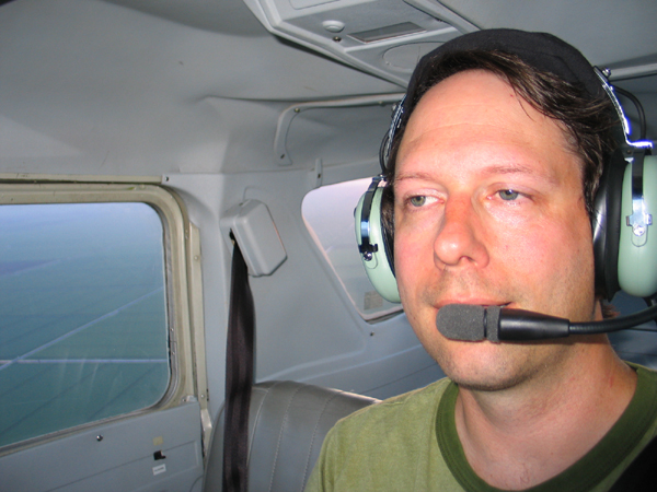 Notice the empty
right seat! You can also see the sugar cane fields of the practice area.
I found the landmark to indicate the turn to the east for the airport (a series of four canals dug in a perfect square). I made my radio call and headed back to the airport. When I go to the airport, I entered the traffic pattern and came in for a landing. This landing was nice and smooth. It is always nice to end a flight with a good landing. I then taxied clear of the runway, made my radio call, and cleaned up the plane (retract flaps, etc.). As I was getting ready to taxi back to the ramp, I noticed a baby deer and two adult deer by the side of the taxi way. I tried to snap a picture, but it was too dark. There was another plane on approach, and I wanted to make sure they were not headed for the runway. The other plane did a missed instrument approach, and the deer moved away from the runway. Then I taxied back to the ramp and tied down the plane. Then I got to do one more new thing: I filled out an entry in my logbook! Up until this time, it was always filled out by my instructor. It was a really nice flight and lots of fun. My next lesson is Saturday, where I learn all about radio navigation.  9/08/07 Radio Navigation Before we went out to the plane today, Mike went over what we would be doing. The main purpose of today's lesson was to get some experience with using the radio navigation systems in the plane. Also, I would be getting some instrument time towards my 3 hours of required instrument training. Mike showed me what the needles on the VOR (VHF Omnidirectional Range) and the ADF (Automatic Direction Finding) worked. The VOR defines a specific heading towards or away from the VOR station, where the ADF only shows you the direction of the station from where you are. After that, I went out and pre-flighted the plane. It needed gas again, so I called up for the gas truck. While we were waiting I told Mike about my solo flight the other day. Once we got in the air and headed towards the practice area, Mike had me put on the Foggles so I could only reference the instruments. Last night I watched one of the DVDs that had a pretty good explaination on how to do instrument flying. I thought I had a pretty good idea of what I needed to do. I did, but what I didn't think about was that I would be using the VOR and ADF under the hood also. I was also using the chart to look up frequencies and verify I had the navigation radios tuned to the proper frequency. This made it a little harder to keep my scan going and make sure the plane stayed on course. The one thing I did pretty good, though, was to make sure I trimmed the plane erally good so that it would stay at the proper altitude and airspeed. We tuned in the Pahokee VOR and I intercepted a radial. Then I followed the radial towards the airport. Once we got close, I took off the foggles and we entered the pattern. The radio here was really busy, I think because we were getting another airport that uses the same frequency and it was difficult to tell what was going on. We only saw one other plane in the pattern. I entered the pattern and came in for a landing. I had never landed at this airport before, and it showed. I was too high and too fast as I came up to the runway. I came in hard and bounced the plane. We then did a go around a took back off. That was probably my worst landing in about three or four weeks. The thing I did wrong there was not doing a go around right off the bat. I new it didn't look right, but I tried to save it. As soon as I recognized it was bad, I should have executed a go around and started over. We took off and instead of doing another landing, we then went on to practice using the ADF. Mike tuned it into a station and we tracked it in. We flew directly over the antenna and watched the needle go from pointing ahead to pointing behind the plane. One thing you have to do when using an ADF is listen to the station to make sure it stays on the air, since there is no other indication if the signal is lost. This station was playing some sort of preacher. It was somewhat annoying and made it difficult to concentrate. Music would have been better. After the lesson, I tried to find the station on the chart, and Mike told me it was just a regular AM radio station, since the ADF stations are being phased out. After that, we turned back to North County airport, and used the VOR to get the correct heading. Mike wanted me to fly an ILS approach to see how it worked. ILS approaches are not required for the private pilot training, but it would be something good to see. ILS approaches are a large part of the instrument rating. I did the approach without the hood on, so I could see what was happening. Basically, the approach is a VOR radial and a glide slope indication. When everything is lined up, it forms a crosshair on the instrument. If you keep the needles in the correct spot, it will take you right down to the runway. I did pretty good at it and we took the plane all the way in for a landing. This landing was better than the one at Pahokee, but I have done better. I think my landings were not so good today, because of all the new stuff I learned and did distracted me. The next lesson is flight planning for my first dual cross country. I scheduled that for Wednesday night. No flying during that lesson, but I will do my dual cross country next Saturday, and my solo cross country next Sunday. It takes more time to do the cross countries, so I have to schedule the plane for longer. That means cross countries are basically going to have to be done on the weekend. The syllabus says to do the solo cross country as soon as possible after the dual (since they are both to the same place), so that you don't forget anything. Of course, getting to the cross countries means I need some more stuff. After my lesson I bought a new sectional (the last one expired at the end of August), a plotter, and an E6-B. The E6-B is basically a slide rule for calculating wind drift, fuel usage, etc. There are electric ones out there that work like a calculator, but they are more expensive and it's not like this is anything that difficult. I plan on trying to do as much flight planning before my next lesson as I can, so I am prepared. Hopefully the weather will cooperate next weekend and I can get both flights in. 9/12/07 Cross Country
Flight Planning My first cross country will be to the Labelle airport (X14). It is about 65 nautical miles from my airport. The cross country flight will be a straight shot out to Labelle and back. We will only be doing a touch-and-go at the airport before we head back. The first part of planning for a trip is to take the chart and draw a line from the start to the end of the trip. That was easy for this one. Next, you select landmarks to help you stay on course. I had selected a few, and Mike suggested a couple others. Finally, we selected an elevation to fly the route. We selected 4,500 feet, but I have my doubts that we will actually be able to fly that high this time of year. So far this summer, the clouds build at around 2,500 to 3,000 feet. This trip is too short and the 152 is too weak to fly over the clouds, so I think we will end up doing the trip at 2,000 feet. The flight is early in the morning, so who knows, maybe it will work out. Then we walked through the process of calculating the flight parameters, including time to climb to the cruise altitude, wind correction, and compass correction. We used the current winds, so of course that will all have to be adjusted first thing Saturday. We worked our way through the entire trip to Labelle, and I will have to do the return trip on my own before Saturday morning. The whole flight shouldn't take more that about and hour and a half to complete (out and back). In order to keep my training moving, I am then going to do my first solo cross country Sunday morning. The trip is a little too far to do after work, so I would have to wait for the following Saturday to do it if I don't go on Sunday. Plus, the flight will still be fresh in my mind and I won't have to worry about forgetting anything. Mike is not working on Sunday, so another flight instructor is going to endorse my logbook for the flight on Sunday. He will basically review my flight plan to make sure there are no major problems. Since it will be nearly identical to the one on Saturday, I'm not worried about it. That's all for today, no flying on this lesson. My next write-up will be Saturday after my flight. 9/15/07 Dual Cross Country My lesson was scheduled for 8am. My alarm went off, but I had trouble getting out of bed. I didn't have time to do a final check of the weather before heading to the airport. The weather was fine, but I needed the current altimeter and winds to calculate my ground speed for the flight. Since the flight time was only going to be about an hour and a half, and I had scheduled the plane for four hours, I figured I would have time to do it once I got there. Mike was already there when I arrived, so we went to the briefing room so I could finish the flight plan. As it turned out, the winds were very light, so the calculations did not do much to my speeds. Once that was done, I headed to the plane to do my pre-flight. That was done, and we headed out at 9:45 am. The plane was full of fuel and people, so the climb performance was a little less than normal. This caused us to miss our first checkpoint. We should have been at the top of the climb (4500 feet) by then, but we were still a little low. By the second checkpoint we were at the proper elevation, so we started the clock so we could time ourselves to the third checkpoint. Once we arrived at the third checkpoint, we used the E6-B to calculate our ground speed. It was slightly higher than I had planned, but not enough to really make a difference. We had to dodge around one cloud that was building on the west side of Lake Okeechobee, but other than that, it was a pretty straight shot to Labelle. Up at that altitude, the air was pretty cool (around 68 degrees), and it was also smooth, since we were above the clouds. It was a little hazy, but you could still see quite a ways out. Another new thing we did on this flight was to use Flight Following. That is where you talk to Air Traffic Control (ATC), and they warn you if any other planes are near you so that you can find them. We started by talking to Palm Beach Approach, and then they handed us over to Miami Center, who handed us over to Ft. Myers Approach. Ft. Myers Approach dropped us once we could see the Labelle airport. Talking to ATC was fine, other than it was one more thing to do while flying. It added a little more to the workload, but I felt that I handled it pretty well. As we approached the Labelle airport, I was happy to see it right off the nose of the airplane. That meant my flight planning (and flying) was accurate. Very cool! We then tuned the radio into the airport frequency. The bad thing about this particular frequency is that it is also shared by the Pahokee airport on the other side of the Lake. I think they are a little too close to share a frequency, since you can hear both airports from either one. It just makes the pattern seem more crowded than it is. Having said that, the Labelle airport is a fairly busy airport (at least on Saturday morning). There was a lot of activity in and out of there. We overflew the airport and turned into the downwind leg behind another plane that was doing touch and goes. I turned base and final, but I was really high. As we got close to the runway, I told Mike I was thinking of going around. He thought I could make it, so I went ahead and tried. I got down, but I was further down the runway than I would have liked. Plus the landing was a little hard. But, we made it down OK, and still had enough runway to take back off and head back East. On the way back, we tried to get Flight Following from Ft. Myers Approach, but after two calls with no response, we decided they were too busy to handle us, so we continued on our way. The flight plan called for returning at 3500 feet, but the clouds were really building, so I wasn't sure if we would be able to maintain that. Then we tried to get flight following from Miami Center, and they could handle us. By this time the airwaves were really crowded. It was almost constant chatter on the radio. It was had to listen to the radio, keep on course, and listen to Mike at the same time. As we approached the lake, we were still above the clouds on the west side, but it looked like the clouds on the east side were too high already. We followed the south bank of the lake this time, since we were a little lower and probably couldn't glide to the other side if we lost an engine halfway across. Then, as we approached the east side of the lake, we descended to about 1800 feet to stay under the clouds. After we got past Pahokee, we canceled the Flight Following and tuned into the North County frequency. As we were in the middle of the practice area, I looked up and say a plane overfly us by about 800 feet. That was a little too close for comfort. Just listening to the radios made me realize how many planes were in the air. I don't know if today was a busier than normal day, or if it was a normal Saturday, but there a lot of planes in the air around here. I would have to admit that the return trip was a little more stressful than the trip out. With the sharp increase in traffic and the lowering clouds, there was a lot to be aware of. I guess all the time in the pattern and practice area sheltered me a little from what was really happening out there. So, in that respect, it was a good learning experience. After the close encounter (well, close for me, anyway) we continued to the airport. I had another unspectacular landing, and that was the end of the first cross country flight. Overall, it was very educational. I was busier than I thought I would be, but that was probably because of the flight following and the number of checkpoints we had. We talked about what happened during the flight, and things Mike wanted to make sure I did tomorrow, on my solo cross country. Overall, the flight went well. My next flight is tomorrow morning, when I get to do the exact same flight again, but this time I will be alone. I am hoping the weather is a tad bit better than it was today, since I will not be flying until 11am. If tomorrow is like today, the clouds will be low and I will have to do the whole flight under the clouds at about 1500 feet. If the clouds get too low, I won't be able to fly. They have to be above 2000 feet or I am not allowed to go. If not, I have already scheduled time next Sunday first thing in the morning as a make up session. 9/16/07 Solo Cross Country Anyway, today's concern was weather. I couldn't get the plane as early as I had it yesterday, so that meant the clouds would be taller and closer to raining than on my flight yesterday. I had the plane scheduled for 11am today (yesterday we left at 9:30am). Mike wasn't working, so I had to have another instructor, John, endorse my logbook for this flight. He had a student from 10-noon, so I had to get there at 9:30 so he could look over my flight plan before his lesson. The only advantage of this arrangement was that if the plane got back early, I was ready to go. I did my flight plan last night. I decided that waiting until the morning to do it was not worthwhile. There are forecasts for the winds up to 24 hours in advance, and they don't change that quickly (at least the upper level winds don't). Plus, I would be timing myself between my checkpoints and would make any corrections needed in the air. Also, I would be back with at least a half a tank of gas, so there wasn't any danger of running out of fuel if the winds were dramatically different. When I got to the airport (at 9:30), the clouds were high to the west, but they were already building to the east. I hoped they would hold off until I was done. I met John, and we went over my flight plan. It only took about 10-15 minutes and he said everything looked good. He signed my logbook, and his student arrived a few minutes later. Then I just sat in the office until the plane I was flying came back. At about 10:15, I saw it had arrived on the ramp. I went in the briefing room and looked at the weather. No rain west of the airport, and dissipating rain to the east. The clouds were at 2500 feet, so I was within my limitations. I grabbed the plane keys and headed out for my preflight. On my way out, I had the guy working the office call down to the FBO to top the fuel off. The fuel truck was already putting gas in the plane when I got down there, so I waited until she was done before pre-flighting the plane. Everything looked good, so I got out my chart, flight plan, etc. and set everything up in the passenger seat. This is all a lot easier without someone sitting there! Before I started the plane, I checked the weather on the field from the automated system and everything was still good. I started up the plane, taxied out to runway 31, did my run-up and took off. As I had suspected yesterday, the clouds had already built higher than my planned cruise altitude. My backup plan was to find a comfortable elevation below the clouds and do the trip that way. That meant it would be bumpier and hotter than yesterday, but that's the breaks when you're flying a Cessna 152. I settled at about 1700 feet and turned to my planned heading. I passed my first checkpoint, the sugar mill, to the left, just as planned. My next checkpoint was Pahokee airport. I tuned the radio into the Pahokee frequency to listen for traffic. Since I was lower than my planned altitude, I decided not to overfly the southern end of Lake Okeechobee. I would not have enough elevation to glide to shore from the middle if something went wrong. Instead, I was going to circumnavigate the south end of the lake. I also decided not to use Flight Following with ATC today. I thought it might be harder for them since I would be avoiding clouds and changing course a lot more frequently than yesterday. I was also not sure how helpful the radar would be with me so low. Since I was lower than yesterday, I had to be a lot closer to things before I could see them. I was about five miles out from Pahokee when I finally spotted it. It was pretty busy with planes overflying the airport as a navigation checkpoint, and students using it for touch and goes. A lot of the flight schools in the area that fly out of towered airports use Pahokee for their touch and go practice because those are easier without a control tower. I was starting to feel a little nervous being that close to all the traffic, so I turned south. I think I was probably a little closer than I needed to be. I made a few radio calls so anyone leaving the airport to the south would know where I was. Once I got further around the lake, I tuned in the Airglades airport frequency. This is a small airport west of Clewiston that has a lot of parachute jumps from. I didn't want to look out the window and see a parachute in front of me! They were doing some skydiving there, but they were not real clear on the radio when, or even if, they were actually jumping. At this point I was listening to two radios at once. The Pahokee/Labelle channel (they share the same frequency), and the Airglades/whatever-else frequency. In the middle of the state I was picking up people in Naples, Homestead, Sebastion and a few others. It didn't help that they were also skydiving over Homestead and Sebastion at the same time. Well, all I could do was listen and keep and eye out for anything. I never did see any parachutes in the sky. Since I was going a slightly different route than yesterday, I used a different technique for navigation. Instead of flying a straight heading, I used pilotage and dead reckoning. That basically means you look out the window and figure out where you are. Since I drive this particular route several times a year, I knew I wasn't going to get lost. Plus, I was just there yesterday. My plan, after going around the lake, was to find the Caloosahatchee River and follow it to Labelle. The Labelle airport is only a couple mile south of the river, so it shouldn't be hard to find. I stayed on the south side of the river to make sure I saw the airport. The radio for the Labelle airport was very quiet. There wasn't the traffic today there was yesterday. In fact, nobody took off or landed at that airport before I got to it. I announced my position as I got closer. I overflew the airport to see which way the wind was blowing. I couldn't find the windsock, so I asked on the radio for a runway advisory. No answer, so I decided to use the same runway as yesterday. I could always abort if it didn't look right. I circled around and joined the downwind leg. Then I turned base and final. I tried to fly a wider pattern than yesterday, since I am now having this tendency to get too close to the runway. That makes my base leg really short, and harder to get lined up with the runway on final. I came in for a landing, and it was a beauty. The stall horn was going off just as I touched down. That is the slowest speed you can land a plane without it dropping on to the runway. It may have been my best to date, and no one was there to see it! No instructor or other planes. I'm not sure anyone was even at the airport today. Figures! I put up the flaps, put in the carb heat, and pushed the throttle in. I took back off and headed back east. My flight back was going to follow the same route as before. I wanted to stay well north of the Airglades airport, so I kept over the river this time. As I was traveling east towards Clewiston, I saw what I thought at first was another plane headed west towards me. I turned a little more to the north to avoid him. When he got closer, I realized it was a powered glider or ultralight. There is a small field they fly out of west of Clewiston. He was lower than me, so there wasn't any issue. Just one more thing to look out for. I brought my camera with me to take some pictures, but it was too turbulent and I didn't feel comfortable messing with the camera. So no pictures today. The way back was basically the same as the way out, but in reverse. This time I stayed well south of Pahokee, since I could easily see the sugar mill I had to head to next. I made a few radio calls as I passed the airport, but the traffic was lighter than before. As I turned to the sugar mill, I saw some rainclouds to the east. There didn't look to be any between me and the airport, but I couldn't be sure until I got to the sugar mill. When I got to the sugar mill, I tuned the radio to the North County airport frequency. I also turned off the Pahokee frequency. The radio was eerily quiet. Usually there is all sorts of traffic there on the weekend. I started to check if I had the correct frequency, when I heard a helicopter talking. Then I knew I had the right frequency. I started to get worried that no one was on the radio because it was raining at the airport and no one was flying. Ahead of me were two storm cells, one to the north and one to the south. They were probably five miles or more apart, but they looked pretty close to me. I decided to go between them and then decide if I was going to continue to the airport. I got some light rain on the windshield as I passed between them, but it wasn't any more turbulent than before. I descended a little also, so I could see more below the clouds. I didn't want a plane to pop out from the clouds with me right below them. I was still in sunshine, so I figured I was OK. I did push the throttle in a little to make sure I had full speed. I didn't want to get caught between them. As I went around the northern cell, I looked down and I was over the square canal. That is the landmark southwest of the airport. That is also about 10 miles away. At least I knew where I was and it wasn't raining here. Then I looked for the airport. I saw it, but it was completely surrounded by rain, except in my direction. I decided that as long as I could see the airport, I would continue. If the airport disappeared in some rain, I would turn around and head back to Pahokee. I was pretty nervous at this point. Here was a situation I had never been in before, and I was alone. I wasn't sure how fast the rain was moving, or if it was even moving towards the airport. I can definitely see the advantage of the Garmin 496. It has realtime nexrad weather from the XM Radio satellite. I would instantly know what the weather was doing. Now, I have lived in Florida most of my life, so I knew the storm cells were very localized and moved pretty slowly. There was a good chance that if I could see the airport, I would be fine the whole way. Plus, I wasn't really sure how close the rain was to the airport. I am not real good yet at estimating distances from the air. The storms could easily have been more than five miles from the airport. I flew a course directly for the airport. Usually, as I fly back to the airport, I can determine what runway is in use by listening to the other planes land. Since no one was flying at the airport, I would have to determine it myself. I probably flew a little too close and too low to the runway, but I wanted a good look at the windsock. At least I knew where to look at this airport. The wind was right down 8R, and of course I was paralleling the runway. I would have to make a 180 degree turn to get on the downwind leg for the runway. I turned a little south to give myself room to make the turn. As I was turning the plane, another inbound plane just called out to the FBO for wind direction. I should have thought of that! Oh well, I was already on the downwind leg. Once again, I was too close to the runway on my downwind leg. My base leg was basically a continuous turn to final. I wasn't sure I was going to get around in time. I really didn't want to have to go around again, since I was afraid the storm would be over the airport before I got down. But, I made the turn in time and got the flaps down and lined up for the landing. The landing was pretty good, all things considered. It wasn't as nice as the one at Labelle, but it was better than either one yesterday. I pulled off the runway and cleaned up the plane. Then I taxied back to the ramp. I tied the plane up and wrote down the time. I couldn't believe it, exactly the same amount of time as yesterday. After I got home, I checked the radar archives at Weather Underground. The rain was definitely around me. I'm not sure if I did the right thing in that situation or not. I think what I did was OK, since really you only need to avoid the red areas in a thunderstorm. The green areas are OK to fly through. The only thing that could have been bad is if I got around the first raincloud and then I couldn't see the airport. I would have turned around, but maybe the two storms would have merged together, trapping me in the middle. I don't know. Here is what the rain looked like about the time I flew through it. The blue line is the approximate path I took with the plane. 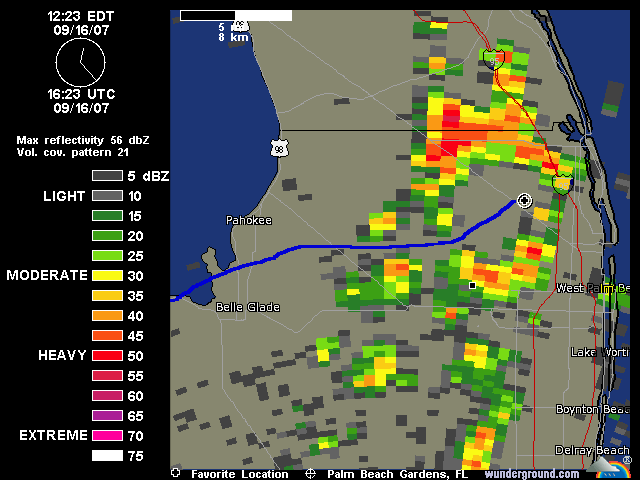 As you can see, there was quite a bit of space around the airport. It wasn't raining when I landed, and another plane came in about ten minutes after me. Most of the rain around my flight path was pretty light, so I wasn't in any immediate danger. It may have been more stressful just because I was alone and had never experienced this before. It was raining when I left the airport for home, but not very hard. Eventually all that rain merged together and headed southwest. If I had left a half hour later, I probably would have had to sit at another airport until the rain passed. If nothing else, it added some excitement to my first solo cross country. And now I have some experience in this weather, which is very common in Florida in the summer. Well, this was another major milestone in my progress towards being a private pilot. I have another dual cross country I have to do, and two more solo cross countries. I also have a lot more practicing of the basic maneuvers ahead of me. In fact, my lessons this week are two practice sessions in the practice area. One with Mike, and one by myself. My next lesson is scheduled for Thursday evening. 9/20/07 Control Tower and
Stalls I also talked to Mike about not using Flight Following, and why I decided not to. He said that I could have used it, I would just have to advise ATC when I was changing course, altitude, etc. Now I know. Next time I will use it. I have also decided that solo cross countries are going to be done Sunday mornings, since the weather is better and air traffic is lower. Tonights lesson in the syllabus was just a flight to the practice area to go over the maneuvers I practiced by myself on my last solo trip to the practice area. Mike thought it would be better if I got more practice talking to a control tower. He suggested that we fly up to Stuart again and do some of the maneuvers on the way up or back. That sounded good to me, so I went out to preflight the plane. Once the pre-flight was done, we took off and headed to Stuart. On the way, Mike asked me about the maneuvers I did in the practice area by myself last time. I told him the only one I didn't feel comfortable with was the power on stall. I think there must be a trick to the setup for them, since it took forever to actually get to the stall the way I have been doing them. By the way, I am doing them the way Mike taught me, but I was curious if there were other ways that might be easier for me. One we were over a state park, we did some clearing turns and climbed up a little bit. Then Mike had me pull the throttle back and maintain my elevation. This would bleed off the speed. Once we got to about 50 knots, he had me push the throttle all the way in and pull back a little more. Within 30 seconds we were in the stall. That was much better than before, since what was making me nervous was the wait for the stall to happen. This way it was quick and painless. The reason we slowed to 50 knots was that is the rotation speed for this plane. The power on stall is supposed to get you familiar with a stall that would happen during take off. The power off stall is to get you familiar with a stall during landing. Anyway, I like doing the stall that way, since it was easier and faster to set up. My previous method was to just pull back on the yoke until the plane stalled. This took several minutes, and the plane climbed about 1000 feet during this time. Plus, you had all that time to anticipate the break of the stall. The new way is much better. We did about five power on stalls so I could get familiar with this new method. I don't always keep the wings level, which makes for a more exciting stall. But using the rudder pedals will straighten that out and I did it several times. After that we continued on to Stuart. I first had to listen to the ATIS broadcast, and then call the tower to let them know I had the info from the broadcast. He cleared me to land, and I entered the downwind leg for runway 12. Once again, my pattern was too close, and my base turn was basically a big turn into final. I really need to practice some pattern flying at a different airport than North County. Anyway, I got aligned with the runway and brought the plane in for a landing. I was a little high and dropped the plane to the runway, but no bounce. Not great, but not awful, either. We took back off and headed back to North County. On the way back, I mentioned that I had trouble trimming out the plane on my solo cross country. Mike thought we should practice that on the way back. Once the plane was back to cruising altitude and speed, I trimmed the plane. Then Mike had me take my hands off the yoke to see what happened. The plane started to descend, but Mike wouldn't let me correct it. After a few minutes, it leveled off and started to climb again. It repeated this oscillation several times. Mike said that was normal, and eventually it would naturally slow to rest at one elevation. Then he told me to steer the plane without touching the yoke, only using the rudder pedals. By making small corrections with the rudder pedals only, you could keep it on course. The advantage of this is that now your hands are free to mess with a chart or write down a clearance from ATC. I thought this was a useful skill to have. He also said this would make instrument flying much easier to know this trick. I flew with only the rudder pedals all the way to the airport. I didn't touch the yoke until we were ready to enter the traffic pattern. By the time we got to the airport, it was dark. That was OK, because I need some night practice anyway (my next lesson is also night flying). I overflew the airport and tried to enter the traffic pattern. I somehow got disoriented and thought another runway was the one we were going for. Mike kept directing me away from it to line me up with the correct one. Finally, I was on final for the proper runway. We were going to do a little landing practice, but I had already been flying for an hour, and was a little confused with what happened. So we decided to just land the plane and end the lesson for the night. I had a little trouble getting lined up for final, but I brought the plane down for a really nice landing. After we landed, Mike said, "You sure are getting good at saving landings." Little does he know all my landings are saves. The stable approaches are the rare ones! Anyway, after we landed, Mike showed me where I got confused on the way in. It wasn't a big deal, since night flying can sometimes be disorienting. That is why I have to practice it. My next lesson with Mike will be full hour introduction into night flying, and then after that, my night dual cross country. My next flight, however, is Saturday all by myself. I am going to head to the practice area to practice more maneuvers. I am also planning on going to Pahokee to practice landings at an airport I am not used to. I will say, that other than my confusion right at the end, that I am starting to feel more comfortable with the plane. Even the power on stalls, which had always worried me, are now starting to feel more natural. Mike says my radio work is good, but I am not convinced yet. When he is in the plane, I can ask him what I am supposed to say. That is different than when I am by myself. Well, I guess that is why we do the solo cross countries. Oh, one more minor milestone completed tonight. I now have 30 dual instruction hours, the minimum required by the FAA. That is kind of irrelevant, since there is still some more required dual instruction ahead. But none-the-less, I am getting closer to the end! 9/22/07 Using a Different
Runway I arrived at the airport and grabbed the keys to the plane. Then I headed out to the ramp to pre-flight the plane. The weather was fine, but it was the typical Florida summer, with cumulus clouds building throughout the day and raining in the afternoon. I took off using the short field technique, and headed west to Pahokee. I tuned in the VOR so I could practice navigating with it. The tops of the clouds were low enough that I could climb on top, but I stayed low since I was just going to land at a relatively close airport. The air traffic today was busy, but nothing like last Saturday. There was no one at Pahokee when I arrived, but I could hear a couple other planes inbound on the radio. I overflew the field and checked the windsock (I could find it at this airport). The runway runs basically north/south and the wind was from the east, so I would get to practice crosswind landings also. The runway is not perfectly north-south, so I selected the runway direction that had the most easterly direction. I entered the downwind leg and set up for the landing. Landing in this direction puts you over the lake on base and final. My first landing was a little crooked, and I side loaded the landing gear a little. I had decided all my landings would be full stop so I could practice the different take-offs. My next take off was a soft field. In this one, you pick the nosewheel off the ground and get in the air as soon as possible. I lifted the nosewheel too high, and had some trouble keeping the plane going straight down the runway. But I managed and took off again. The second time around, my landing was acceptable. I went taxied back and did a normal take-off. I went around one last time and did a normal landing. I was going to do a touch and go this time, but once I was on the ground I decided to do a full stop and taxi back. Then I did a normal take off and started to head back to North County airport through the practice area. When I got to the practice area, I did some S-turns across a road, and then a half-hearted attempt at turns around a point. It was getting late and I didn't get my set-up good, so I just headed back to the airport. I arrived at the airport and made a pretty good landing. I was surprised I was gone as long as I was, since it didn't seem that long. My next lesson is Wednesday with Mike. That is my first "official" night flight lesson, so it doesn't start until 8pm. After that is my night cross country to Vero Beach. |
[Home]